Stevens Trail was a toll path that connected the mining communities of Colfax and Iowa Hill. It was in operation from 1870 to 1895, years when these parts saw a lot of mining activity. Then it was abandoned and largely forgotten. In 1969, a Boy Scout from Sacramento rediscovered it and took on its charting as a scouting project. It's now listed on the National Register of Historic Places, and is one of the most popular trails on the North Fork of the American River. In fact, its popularity and heavy use kept me away from it, for I prefer my trails uncrowded. But with it being the off season, I knew few hikers would be on it today, so I took my first hike on it.
From the trail head at Colfax, the trail traverses Slaughter Ravine and Robbers Ravine, names that recall the violence of the Gold Rush. It passes under the famed railroad prominence of Cape Horn, of which I have previously written. It passes Nisenan grinding rocks and abandoned mines. And at Secret Ravine it reaches the North Fork of the American River. The bridge is long since gone, but from here the trail continued up Iowa Hill Divide to Iowa Hill.
The trail drops some 1200 feet over about 4.5 miles, making for a very easy hike.
The trail was muddy from recent rains. The light on the moss on the trees at the start of the hike made for a pretty sight.
I reached a large slate outcrop under the Cape Horn prominence. I couldn't see the river from here but I could see the paved road to Iowa Hill. There were two holes in the slate, made by Nisenan women who over the centuries ground acorns and other seeds at this spot. I'm sure they enjoyed the view of the canyon. Some three hundred feet above was the retaining wall at Cape Horn. I've peered over that wall. The railroad frowns on this.
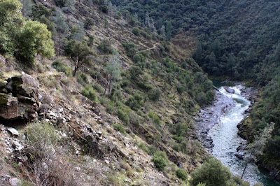
I continued on. I got a good view of the North Fork and the modern bridge that connects Colfax and Iowa Hill. The second photo below shows the trail some 200 or 300 feet above the river. It does no justice to the actual view.
The river was running high, but tree limbs and tree trunks some fifteen feet above the current water level attested to the heavy rains we had a few weeks earlier.
I passed two separate camps enroute to the river. I saw the occupant of one camp, a man who looked to be in his fifties. This is public land and here and there people set up camps for long periods. They are looking for gold or they just want to get away from civilization.
I reached the river at noon. I took a GPS reading. The elevation was 1216 feet. It was warm enough to wear only a tee shirt, but I kept on my fleece vest. There was some nice gravel behind a large slate rock at the river, and I reminded myself to bring my gold pan on my next hike.
And since this was such a nice trail, that next hike should be pretty soon.


No comments:
Post a Comment