 |
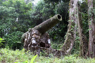
| Spanish cannon on Camino de Cruces. |
The Spanish cannon has been guarding Camino de Cruces since, well, when the Americans set it there in the Canal Zone era.
 |
| Overlooking Madden Highway. |
Camino de Cruces is also called Camino Cruces, Sendero Las Cruces, and El Camino a Cruces, among others. Built in the early 1500s, it was once the main route across the Isthmus of Panama. (A second route, El Camino Real, between Panama City and Portobello, was primarily used for the transport of Incan gold and silver.) Travelers heading to Panama City would take native cayucos up the Chagres River to the town of Cruces, and then proceed overland by foot or mule.
 |
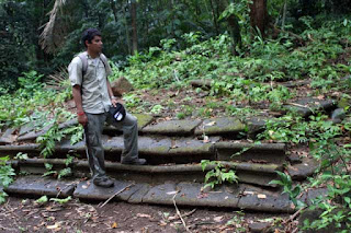
| Many sections of the trail contain the original cobblestones. |
That most of the trail was in the former Canal Zone undoubtedly saved it from destruction by development. When Panama assumed control of the canal, it designated the area a national park.
I had wanted to hike Camino de Cruces for several years. On this past trip to Panama, I secured a topographical map showing the trail from Instituto Tommy Guardia at the University of Panama. The map had "Ruinas" marked at the bank of the Chagres River. This was the site of Cruces. I wanted to go there.
My niece's husband and I set out early in the morning. We carried the map and plenty of water. I had my GPS, but in some areas it could not receive satellite signals due to the ravines and the dense jungle canopy. A compass would have been more useful. Especially in that one spot where we wandered off the trail and were sort of bewildered for about twenty minutes.
We left the trailhead at Madden Highway and entered the jungle. I had to set my digital camera to a high ISO to take photographs without blur. The distance from the Madden trailhead to Cruces was about 6.2 miles.
The trail crossed a rock outcrop. Countless mules and horses had traversed Camino de Cruces over some four centuries, and their hooves had worn impressions into the rock.
 |
| Hoof print worn into rock. |
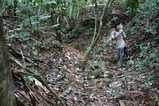
The trail wound through ravines and went over hilltops and across streams. Sometimes we had to make our way around a tree fallen across the trail. The footing could be precarious but this was not a place to grab onto a rock or a tree branch for support. Here live all kinds of nasty critters, and even the plants with their nettles and thorns are unfriendly.
Camino de Cruces saw heavy use during the California Gold Rush, and many journals detail the crossing. It was also a transit route for the United States military. In 1852, Lieutenant Ulysses S. Grant and his unit, headed to Oregon, were delayed on the Isthmus for six weeks, and the tropical diseases took their toll. In his Personal Memoirs, Grant wrote: "About one-seventh of those who left New York harbor with the 4th infantry on the 5th of July, now lie buried on the Isthmus of Panama or on Flamingo island in Panama Bay."
We reached the ruins of Cruces and the Chagres River. Cruces went into decline with the opening of the Panama Railroad. The creation of Gatun Lake during the canal construction submerged any buildings at a lower level. The Americans removed the remaining residents of Cruces, as the town was within the Canal Zone. Today only the stone foundations of a few buildings remain. Panama has erected some interpretive historical signs on the site.
 |
| The Chagres River, with Gamboa Rainforest Resort in the distance. |
 |
| Steps to the church at Cruces. |
We commenced the return hike. Shortly after leaving the ruins, we paused to watch a howler monkey in the tree canopy above, and we listened to its strange howling noise. We had no problems with mosquitos but we did pick up a lot of chiggers. The heat and humidity could not be ignored, and we had to stop a few times to cool down. We met only one other person on the trail, an Austrian headed to the river. We told him he did not have enough time to go there and return before nightfall, so he turned around. As for ourselves, we reached the car at Madden Highway with about one hour of daylight to spare.


No comments:
Post a Comment