Saturday, May 28, 2011

Isla Taboga

For such a small island, a lot of things have happened on Taboga. Its recorded history begins on a sad note: In 1515, Spanish soldiers landed on the island and proceeded to kill and enslave the Indians. Not an uncommon thing in those days. Then the English came and killed some of the Spanish. They returned several times, and there was more bloodshed. Then the English returned, in peace, to establish a base for a steamship company. Then the French came to build a retreat for their canal workers. And then the Americans came, one of them being me. In the Canal Zone days, Taboga Island was a great place to spend a free day. It's about ten miles from the Pacific entrance to the Canal.

Much time had passed since my last visit to Taboga, and on this past trip to Panama it was time to return.

Years ago the boat departed from Balboa, and now it departs from Naos Island at old Fort Amador. We had some time to spare before leaving, so I took a short walk to the site of a coastal artillery battery. Several batteries are tucked away here and there around both entrances to the Canal. The concrete storage rooms of Battery Buell are now being used by the Smithsonian Tropical Research Institute. (Note: These batteries were named after Civil War generals.)

Artillery at this site once defended the Pacific entrance to the Canal.

We boarded the boat and were on our way to Taboga.

Looking back to Panama City.

Arrival at Taboga.
I did not recognize any of the buildings on Taboga. What remained from years ago, the passage of time had erased any memory of them. When I looked at the old church, it was as if I was seeing it for the first time, although I had seen it before. I know Taboga has grown over the years, but I could not remember how big it once was.

The old church on Taboga.

We visited a bit with some of my wife's relatives who live on the island. My wife in her youth would spend part of her school break with these relatives.

We then walked to the house where my wife's grandfather had lived. A sign on the house stated that it was the birthplace of Rogelio Sinan, a noted Panamanian writer. My wife said she is related to Rogelio Sinan, but she does not know the exact lineage.

My wife's grandfather's house on Taboga.

In 1920, the United States exercised its treaty rights and took control of parts of Taboga Island for the defense of the Canal. Residents of Taboga Island protested this seizure. The island has erected a sign commemorating their actions, and it includes the names of some of my wife's relatives. This was all news to her.

Reading family history.

We then walked to the Taboga graveyard. My memory had the graveyard right in the middle of town, but it was on the outskirts. The graveyard is in terrible shape: weeds were everywhere, tombs were falling apart, and headstones were broken. My wife has relatives buried here, but she is not sure where the plots are.

Poking around Taboga Cemetery.
I didn't forget everything about Taboga. I remembered the cross atop the hill, and I hiked alone to it.


View of Taboga from the base of the cross.
From the cross, I wanted to hike to another part of the island, but rain started to fall, so it was best to return. The rocky trail was a bit slippery going downhill, but soon I was on level ground. I joined the others at the dock. A short time later we departed.

Return to Panama City.

Sunday, May 22, 2011

Fort San Lorenzo


Fort San Lorenzo is far and away my favorite historical site in Panama.

Lots of bloody battles?: Check. Great subjects for photographs?: Check. Hardly anyone else around?: Check.

The Spanish built Fort San Lorenzo at great expense on a promontory at the mouth of the Chagres River, to guard the Caribbean end of the main travel route across the Isthmus. It was attacked several times, and taken a few times. Some of the cannons on the site are British.

View of Fort San Lorenzo from the site of Chagres.

Spain departed the fort in 1821. It served as prison for some years before being abandoned. During the California Gold Rush, curious travelers stopped at the town of Chagres would make their way to the ruins. With the completion of the Panama Railroad, traffic on the Chagres River was sharply reduced, and Chagres dwindled away.

The fort was within the boundaries of the Canal Zone. The United States cleared the jungle vegetation from the ruins and built a paved road to the site. Panama now includes Fort San Lorenzo in a national park.

Looking out to the Caribbean.

View up the Chagres River.

The storage rooms carved into the promontory give a respite from the blazing sun.


I could bore you to tears with Fort San Lorenzo photos, so I'll stop with these.


Thursday, May 19, 2011

Modern Ruins of Fort Sherman

Traveling between Gatun Locks and Fort San Lorenzo, one passes through the former Army base of Fort Sherman. The United States turned this real estate over to Panama under the terms of the treaty. Sadly, Panama has neglected some sections of Fort Sherman. We saw a row of houses, just a two minute walk from the white sands of the Caribbean, which were given to Panama in perfectly good condition. Rather than renting them out for a profit while figuring what to do with them in the long term, the government of Panama let them sit uninhabited and untended. The tropical climate took its toll, as did some vandals, and now the houses are so deteriorated that they must be demolished. A shame.


Gatun Locks


I have crossed Gatun Locks by vehicle many times but never once stopped for a good look at the Locks themselves. This, despite Gatun Locks being the grandest of the three original locks of the Panama Canal. (Additional locks are being built as I write this.) So, on this past trip, I made it a point to correct this matter.


Gatun Locks gets fewer visitors than Miraflores Locks. This is easily understood. Miraflores is near Panama City which has many tourists. Gatun is near Colon which is avoided at all costs. As such, Miraflores gets a grand visitors center, while Gatun gets a smaller but still respectable viewing structure. Meanwhile, poor Pedro Miguel Locks gets hardly a notice, with only two or three concrete benches behind a chain link fence provided to the intrepid traveler.

View to the Caribbean.

A ship coming in from Gatun Lake, headed to the Caribbean.

A "mule," which pulls ships through the Locks.

In the late Seventies I drove across Gatun Locks and saw one of the chambers drained of water for maintenance. That was an impressive sight. The photo I took of it does not capture the size of the chamber, so I will not post it here.

We left Gatun Locks and drove to nearby Gatun Dam. This was my first visit. Gatun Dam was once the world's largest earthen dam, and Gatun Lake once the largest artificial body of water.

An earthen section of the dam. The ships in Gatun Lake await
transit through Gatun Locks.

The concrete portion of Gatun Dam.

The dam spillway, with the Chagres River flowing to the Caribbean.

We left the dam and headed to Fort San Lorenzo. On the return trip, we had to stop and wait for a ship to transit Gatun Locks.

Ship transiting Gatun Locks.

Passing a gate as we cross a chamber.

The ship we waited for, headed to the Caribbean

Wednesday, May 18, 2011

Camino de Cruces

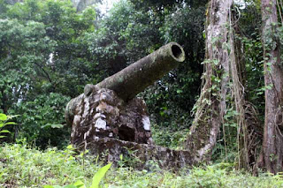
Spanish cannon on Camino de Cruces.

The Spanish cannon has been guarding Camino de Cruces since, well, when the Americans set it there in the Canal Zone era.

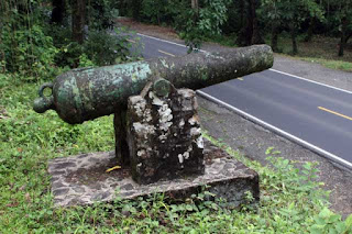
Overlooking Madden Highway.

Camino de Cruces is also called Camino Cruces, Sendero Las Cruces, and El Camino a Cruces, among others. Built in the early 1500s, it was once the main route across the Isthmus of Panama. (A second route, El Camino Real, between Panama City and Portobello, was primarily used for the transport of Incan gold and silver.) Travelers heading to Panama City would take native cayucos up the Chagres River to the town of Cruces, and then proceed overland by foot or mule.

Many sections of the trail contain the original cobblestones.

That most of the trail was in the former Canal Zone undoubtedly saved it from destruction by development. When Panama assumed control of the canal, it designated the area a national park.

I had wanted to hike Camino de Cruces for several years. On this past trip to Panama, I secured a topographical map showing the trail from Instituto Tommy Guardia at the University of Panama. The map had "Ruinas" marked at the bank of the Chagres River. This was the site of Cruces. I wanted to go there.

My niece's husband and I set out early in the morning. We carried the map and plenty of water. I had my GPS, but in some areas it could not receive satellite signals due to the ravines and the dense jungle canopy. A compass would have been more useful. Especially in that one spot where we wandered off the trail and were sort of bewildered for about twenty minutes.

We left the trailhead at Madden Highway and entered the jungle. I had to set my digital camera to a high ISO to take photographs without blur. The distance from the Madden trailhead to Cruces was about 6.2 miles.


The trail crossed a rock outcrop. Countless mules and horses had traversed Camino de Cruces over some four centuries, and their hooves had worn impressions into the rock.

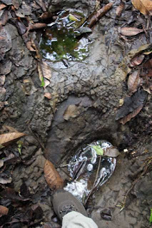
Hoof print worn into rock.

The trail wound through ravines and went over hilltops and across streams. Sometimes we had to make our way around a tree fallen across the trail. The footing could be precarious but this was not a place to grab onto a rock or a tree branch for support. Here live all kinds of nasty critters, and even the plants with their nettles and thorns are unfriendly.

Camino de Cruces saw heavy use during the California Gold Rush, and many journals detail the crossing. It was also a transit route for the United States military. In 1852, Lieutenant Ulysses S. Grant and his unit, headed to Oregon, were delayed on the Isthmus for six weeks, and the tropical diseases took their toll. In his Personal Memoirs, Grant wrote: "About one-seventh of those who left New York harbor with the 4th infantry on the 5th of July, now lie buried on the Isthmus of Panama or on Flamingo island in Panama Bay."


We reached the ruins of Cruces and the Chagres River. Cruces went into decline with the opening of the Panama Railroad. The creation of Gatun Lake during the canal construction submerged any buildings at a lower level. The Americans removed the remaining residents of Cruces, as the town was within the Canal Zone. Today only the stone foundations of a few buildings remain. Panama has erected some interpretive historical signs on the site.

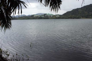
The Chagres River, with Gamboa Rainforest Resort in the distance.


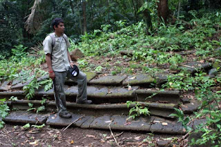
Steps to the church at Cruces.

We commenced the return hike. Shortly after leaving the ruins, we paused to watch a howler monkey in the tree canopy above, and we listened to its strange howling noise. We had no problems with mosquitos but we did pick up a lot of chiggers. The heat and humidity could not be ignored, and we had to stop a few times to cool down. We met only one other person on the trail, an Austrian headed to the river. We told him he did not have enough time to go there and return before nightfall, so he turned around. As for ourselves, we reached the car at Madden Highway with about one hour of daylight to spare.