
Thursday, December 6, 2012
Approach to Tinker Knob
Work has been busy lately, and it and the weather have kept me indoors. My thoughts turn to the Sierra. If I can't go there, at least in my spare time I can draw a picture. Here is the view from the crest of the Sierra, looking south to Tinker Knob, some three-quarter mile away. It is late June, so there are still large patches of snow about.

Friday, November 9, 2012
Gone Are The Days
I grew up in the San Francisco Bay Area, my home town was a short distance from Berkeley.
It is late 1967. I am eleven years old and in sixth grade. One day, our teacher introduces two men who will speak to us. They are with the National Rifle Association. They want to sign up students for a firearms safety and marksmanship class, to be held on Saturdays for several weeks at the police department's firing range by San Pablo Bay. Several of us boys apply.
Our house has no firearms but my friend and classmate, who lives down the street, has a .22 rifle. So over the course of several weeks, my friend and I go to rifle practice on Saturday mornings. We walk through town with the rifle, a box of ammunition in our pockets. We spend the morning at the range. Then we walk home. We often stop at a market to buy a soda. We can't take the rifle inside, so I hold it while my friend goes inside, and he holds it while I go inside. Adults walk past us. The police station is just around the corner. Then we head back home with our sodas and the rifle and the ammunition in our pockets. It's just a normal day in this Bay Area town in 1967. Unremarkable, really.
A glimpse of my past. A simple account of something that, when it happened, was ordinary. But with the passage of years, it shows what we have lost in this country.
Sunday, October 28, 2012
Lovers Leap

Lovers Leap is a prominence on Moody Ridge that overlooks the North Fork of the American River. I've often seen it from the east, standing at Iron Point and thereabouts, and yesterday I got a blocked view of it from the south at Giant Gap Ridge. Today I decided to stand atop it.
Residences are scattered about the privately owned land on Moody Ridge but the public can access Lovers Leap. The dirt road started getting rough some five hundred yards shy of Lovers Leap, so I parked my truck and walked the remainder of the way.
From the highest point (4139ft) of this tree covered ridge, a trail winds southward, until one reaches a final few steps down to a small ledge. On the south end of this ledge, overlooking the canyon, rises a stone outcrop some three feet high. At the sides of this ledge are...sheer drops. How far straight down, I don't know. I was by myself and I didn't want to make that final descent onto the ledge to find out more. Others have gone there, for their graffiti is carved into the rock. As for me, I preferred to stand back to take my photo.
 |
| The ledge - the North Fork can be seen in the distance to the left of it |
I turned around and walked uphill. At the top I proceeded east, down a trail that led to another overlook. This overlook was far more inviting than the first. Although it had its own rock outcrop with sheer drops beyond, there was more room to move about. So I stood there and pointed my camera east, and took photos of Iron Point, where I begin my hikes to Euchre Bar. The peaks of the Sierra in the distance were dusted with snow from the recent storm.

I left Lovers Leap and drove northeast about two miles, as the crow flies, to a point by the railroad tracks, to get a photo of Lovers Leap and Giant Gap.


While in the area, I stopped to look at the rocks where over countless centuries Nisenan women ground acorns into meal. The Nisenan camped here during the warm months and I'm sure they enjoyed the view of Giant Gap.

Saturday, October 27, 2012
Giant Gap Ridge

I've seen Giant Gap many times from the east. Today I wanted to see it from the south rim of the canyon. I drove up Foresthill Divide to Sugar Pine Road. Patches of snow covered the ground at the turnoff. I parked my truck where Sugar Pine Road meets Iowa Hill Road. These are paved roads. I walked up Elliot Ranch Road, an unimproved dirt road muddy from the recent storm. I passed a camp of deer hunters. Deer season ends tomorrow. I would pass several deer hunters driving the roads this day, and hear shots in the distance.
 |
| Elliot Ranch Road |
A water ditch paralleled Elliot Ranch Road for a short distance. This ditch is not on the topographical map. I would guess it dates to the Gold Rush. Ditches are common along the North Fork of the American River and Bear River. Some are still in use but this one was dry.
 |
| A Gold Rush water ditch |
 |
| Forest scenery |
I walked to the south end of Giant Gap Gulch but large trees blocked a good view of Giant Gap.
 |
| The most I could see |
I backtracked and then headed north on Giant Gap Ridge. A large pine tree had fallen across the road. The damage looked fresh and I wondered if the tree had fallen during the storm this previous week. I crawled over it and continued on.
 |
| Fallen tree |
I reached my destination, the northernmost point of Giant Gap Ridge. Down below (2250 feet below) was the North Fork of the American River, and the bridge at Euchre Bar was 2.6 miles to the northeast (129 degrees). But tall trees blocked a full view of the magnificent Gap. I could not see what I wanted, but still it was a great day for a hike.
 |
| Northernmost point of Giant Gap Ridge |
Sunday, October 21, 2012
Last Hike of the Year on Donner Summit
Storms arrive tonight and Donner Summit is projected to get 18 inches of snow by Tuesday. So today I took in my last hike there for this year. I went with a friend. The elevation at the parking lot is 7108 feet, and Donner Peak is 8019 feet. The winds were brisk, bringing the wind chill probably down to freezing, but we had plenty of layers of clothing. From atop Donner Peak we had a full view of Donner Lake. The members of the Donner Party spent the winter of 1846-47 in camps east of the lake. These emigrants reached the wall of the Sierra too late, for the deep snows prevented their crossing. Food ran low and people died. Some members resorted to cannibalism to survive.
The trails should be mostly free of snow and ready for hiking by mid-June.
The trails should be mostly free of snow and ready for hiking by mid-June.
 |
| My friend at the trailhead |
 |
| Me with Donner Peak in the background |
 |
| View of Donner Lake from Donner Peak. Interstate 80 is to the left. |
Friday, October 12, 2012
Panama, California

Panama is a small town in California, in the San Joaquin Valley, a few miles southwest of Bakersfield. I think most of the residents are of Mexican heritage.
Thursday, October 11, 2012
Buck Owens' Crystal Palace
Work sometimes takes me to Bakersfield, and if I spend the night there, I try to take in dinner at the world famous Buck Owens' Crystal Palace, on Buck Owens Boulevard. It's a marvelous place, filled with mementos of the musician's long career, plus the food is excellent. Buck was a Dust Bowl emigrant to California and here he made it big. Very big. Perhaps my own Okie heritage draws me to the Crystal Palace. My great-grandparents (born and raised in the Missouri Ozarks) with most of their children came to California from Shawnee, Oklahoma, and spent the Depression years in the Sacramento Valley. It wasn't a desperate life straight out of the Grapes of Wrath, but it wasn't a comfortable life either. My great-grandparents are buried in Sacramento, and their children are buried throughout California.


Saturday, September 8, 2012
I Purchased a Personal Locator Beacon
After doing some research on Personal Locator Beacons, I purchased an ACR Electronics ResQLink (Model PLB-375). I registered it with the US Government on the NOAA website. That way, should I ever activate the beacon, the authorities will know that it is me who sent it.
The unit is small and I will carry it with me in all my remote travels. It is to be used only as the last resort. Hopefully, I will never use it.
Having this unit does not give license to taking increased risks. I'm reminded of a planned hike on the Euchre Bar Trail last November. I wanted to try some late season gold panning, for I figured the river level was still low. The day was overcast with cool temperatures. No other vehicles were at Iron Point when I arrived. I started down the trail. The rocks were a bit slick from a recent rain. Some five minutes into my hike, I realized my stupidity. I would likely be the only person on the trail this day. Although I had fire starting items I did not have a jacket, much less a sleeping bag. The temperature during the night would drop to freezing. If I twisted an ankle or otherwise got injured not allowing me to walk, I could be dead of exposure before a search party found me. So I returned to my truck and drove home.
With the ResQLink in a similar situation, I would still turn around.
Monday, September 3, 2012
A Man Recounts His Brush With Death, Providing a Lesson Learned
Today is Labor Day. I went to the North Fork of the Middle Fork of the American River for some exploring. I've been there a few times in recent weeks for gold panning but this time I just wanted to poke around.
Two other vehicles were parked near the trail head. A man was putting camping gear into one vehicle. As I gathered my pack, he walked over to say hello. His first name was Herbert. He was 63 and appeared in top physical shape. He lives in Fremont, California, where he works with a medical device company. He was finishing a solo camping and prospecting trip of several days along the river. He has hiked and camped the canyons of the American River since the 1960s, and he often goes by himself.
We talked about gold prospecting in the area. There are many mining claims along the Middle Fork. He had been working on a friend's claim with some luck.
He's had numerous black bear encounters over the years, so he now carries a Freedom Arms revolver with the .454 Casull cartridge, in a shoulder holster. He's never shot a bear but once he fired two rounds over a sow and her cub to chase them away from his camp. He says the .454 Casull will stop a black bear quick.
He told me of a survival situation he had in 2009 during the Labor Day weekend. He had hiked alone down to the North Fork of the American River, on the Sailor Flat Trail. This trail was built by the Forty-niners, it is very steep, and it leads to remote and rugged canyons. Few people go there. It's not a trip for the unfit. He explored along the river and lost the trail. He had to make his way uphill.
He encountered a large area of manzanita bushes. He crawled through them and atop them and the going was slow and difficult. He came to a rock clearing shortly before darkness fell. He built a small fire.
He was out of water, and being dehydrated he could not eat what small amount of food he had. His clothes were drenched with sweat. The night would be chilly. The fire provided some warmth but he could not sleep.
Morning came and he continued uphill. The manzanita gave way to rocks, which gave way to trees. He was completely lost. The day wore on. He was severely dehydrated and he knew that soon he would lose his reasoning. He could not survive another night in this canyon.
Except...a few months earlier, just for the heck of it, he had purchased a SPOT Personal Tracker, a personal locator beacon, which was in his pack. Now was the time to use it. He pressed the 911 button, which sent his coordinates with a distress notice to a satellite, and then to a GEOS International Emergency Response Center dispatcher, who notified the Placer County Sheriff's Department. It also sent an email with the coordinates and distress notice to his son in Los Angeles.
Before darkness fell, a helicopter arrived, but the canyon was too steep for it to land. The helicopter announced that a ground party would be dispatched. That party arrived in the darkness, and assisted Herbert uphill, where emergency vehicles and his son awaited.
Herbert was very emotional when he gave his account of his rescue, and his meeting with his son. He credits his life to the personal locator beacon, and the actions of the Placer County Search and Rescue Team.
Having heard Herbert's story of his brush with death, I decided I would purchase and carry a personal locator beacon. Although I always tell my wife where I'm going (and sometimes I even print out a map), I never carry even a cell phone with me when I hike alone. Part of it is because there's no cell phone reception in the deep canyons of the Sierra, part of it is because I figure my pioneer ancestors would roll over in their graves if I carried this "help" with me. (The latter is pig-headedness.) But now I'm going to buy and carry one.
We had a good long talk, and then we went on our ways. Herbert drove off for Fremont. I hiked alone into the canyon, taking video with commentary.
Well, almost alone. On the overlook to the river, about one mile from the trail head, a family of four passed me, with a sluice box and pans and other gear, in search of gold. I followed them down the steep steps carved into the slate rock, and continued upstream by myself for about one-half mile. This trail ran about thirty or forty feet above the river. I saw few panning spots of any promise. I returned to my truck.
Saturday, August 18, 2012
A Soldier Returns Home
At the end of our vacation, the aircraft taking us from Texas to California included the body of a soldier, escorted by his friend and comrade, a fellow soldier from his unit.
The escort was in service dress uniform. When I first saw him at the gate, I thought he was a recruiter. Three civilian volunteers wearing orange vests with the words Honor Escort soon arrived. I then thought a wounded soldier would be getting off the plane we would board.
But no wounded soldier departed the plane. Shortly before our boarding commenced, the airline attendant at the gate got on the public address, and announced that our flight would carry the body of a soldier from Fort Hood who died on active duty. The soldier escorting his comrade would go to the ramp to witness the placement of the casket into the aircraft. We were asked to stand in silence while this procedure was performed. We could look out the windows to the ramp below.
All the waiting passengers stopped talking and stood up and looked out the windows. The escort met the airline employees, who removed the flag draped casket from a trailer. The soldier escort saluted. Those airline employees not handling the casket or the flag saluted. The flag was lifted off the casket, and the casket was placed into the aircraft. The employees folded the flag with proper ceremony.
During this whole procedure, the waiting passengers remained standing. They did not move around, and they were completely silent. I doubt I was the only one with tears in my eyes.
The casket now aboard, the escort boarded first, taking a front row aisle seat, so he could be the first off the plane.
As we made our approach to Sacramento, the flight attendant got on the public address and asked us to remain seated upon reaching the gate, until the military escort left the plane. An Army honor guard awaited us at the ramp. All passengers remained seated and were quiet. From my seat I watched preparations for the removal of the casket. Once the escort left the plane, the passengers quietly got out of their seats and gathered their belongings. There was no rush to get out. There were no cell phone calls announcing arrivals. Everything was calm and respectful.
This soldier's death was not combat related. I learned from a civilian escort volunteer at the Dallas - Fort Worth Airport that he had died at Fort Hood from complications from a surgical procedure. Combat related or not, he died in the service of his country, and thus his fellow countrymen showed their respect for him on his final journey home.
Thursday, August 16, 2012
Creation Evidence Museum
While in Texas visiting family, our travels took us to the small town of Glen Rose, about one hour southeast of Fort Worth. Dinosaur footprints found in the nearby Paluxy riverbed led to the establishment of Dinosaur Valley State Park. But wait, there's much much more! In the 1930s human footprints were found alongside the dinosaur footprints! They of course were not left in place, but instead were dug up to show others. The story is told in the Creation Evidence Museum outside Glen Rose. Go to their website if you dare. The human footprints prove that Charles Darwin got it all wrong with that evolution stuff. Dinosaurs and man coexisted! Every word of Genesis is true, and Earth is only about six thousand years old. All those layers of fossils? Caused by the Flood! The geologic doctrine of Uniformitarianism? Never heard of that!


Fortunately, time constraints prevented us from taking the tour, leaving the five dollar admission fee to be better spent at Rahr & Sons Brewery in Fort Worth.


Fortunately, time constraints prevented us from taking the tour, leaving the five dollar admission fee to be better spent at Rahr & Sons Brewery in Fort Worth.

Sunday, August 5, 2012
Atlanta
Work took me to Atlanta for two weeks. Over the weekend I visited some local sites.
Kennesaw Mountain National Battlefield Park
Here Sherman fought Johnston in the Atlanta Campaign. He could not prevail in direct attacks, so he outflanked the Confederates, and went on to take Atlanta. Kennesaw Mountain was designated a national battlefield in 1917.
At 1,808 feet, Kennesaw Mountain is the highest point in the core metropolitan Atlanta area. Its park setting and network of roads and paths attract many walkers and joggers. When I arrived around nine o'clock the main parking lot was already full, so I went to a secondary lot. The elevation gain from the Visitor Center to the summit is 657 feet, making for a pleasant 1.1 mile morning walk, but I took the shuttle bus as my time was limited. Kennesaw Mountain lacks the solitude and vistas of the Sierra Nevada. People were all about. On this overcast and hazy day I could not see across the flatlands to Atlanta.
Oakland Cemetery
Of the some 6,900 soldiers buried in the Confederate section of the cemetery, about 3,000 are unknown. Such was the horror of the Civil War. Sixteen Union soldiers were somehow interred in this section.


The grave site of Margaret Mitchell, author of Gone With the Wind, is popular with photographers.
I chanced upon the grave of a man drowned in the Chagres River of Panama at age twenty. I would guess that he worked on the canal construction, and drowned somewhere between Cruces and Chagres. A long stretch of the river for sure, most now under Gatun Lake.
Update: On the Internet I found his obituary, published in the Panama Canal Record:
Gordon Burton Smith, of Atlanta, Ga., a civil engineer in the employ of the Panama railroad, was drowned in the Chagres River near Gamboa bridge on the afternoon of August 20. He was crossing the river in a native canoe which was swamped. Two laborers who were in the boat with him escaped. Mr. Smith came to the Isthmus on January 30, 1908, and was employed in the Pacific Division until January 18, 1909, when he transferred to the relocation of the Panama railroad. He was 20 years of age. The body was recovered near San Pablo shortly after midnight Sunday, and was shipped to Atlanta, Tuesday, August 24.
Elsewhere:
A Card of Thanks. As friends of the late Gordon Burton Smith, and on behalf of his family, we wish to thank all those who assisted in the search for his body, from the time of his drowning in the Chagres River at Gamboa, on August 20, until the body was recovered at San Pablo on the night of August 22. Louis E. Wilcox, A. R. James. Corozal, August 23, 1909.

Martin Luther King, Jr. National Historic Site
I grew up near Oakland, California, birthplace of the Black Panther Party, which chanted "Off the pig!" Thank God Martin Luther King's call for non-violence as a response to centuries of oppression prevailed.


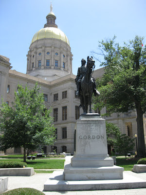
State Capitol
Outside the capitol are signs, placed by the Atlanta Chapter of the United Daughters of the Confederacy in 1920, describing the fall of Atlanta. General William Tecumseh Sherman's siege was a "reign of terror." His order to evacuate the city was "merciless." Sherman's taking of Atlanta and his subsequent March to the Sea are still controversial. I'm with Sherman on this one. The South started the war by firing the first shot at Fort Sumter. The war they thought would last a few weeks dragged on with no end in sight. Sherman saw that to speed the war's end and save lives in the long run, the infrastructure that supported the troops had to be destroyed. So Georgia howled and South Carolina got it even worse. But Sherman let up on North Carolina, which hadn't been as deep into secession as her sisters. In North Carolina Sherman and Johnston met again in battle. Johnston surrendered to Sherman, and the war soon came to a close.
CNN Center
I'm a Fox News guy myself, at least until Erin Burnett comes on.

Kennesaw Mountain National Battlefield Park
 |
| Kennesaw Mountain with Visitor Center and Cannon |
Here Sherman fought Johnston in the Atlanta Campaign. He could not prevail in direct attacks, so he outflanked the Confederates, and went on to take Atlanta. Kennesaw Mountain was designated a national battlefield in 1917.
At 1,808 feet, Kennesaw Mountain is the highest point in the core metropolitan Atlanta area. Its park setting and network of roads and paths attract many walkers and joggers. When I arrived around nine o'clock the main parking lot was already full, so I went to a secondary lot. The elevation gain from the Visitor Center to the summit is 657 feet, making for a pleasant 1.1 mile morning walk, but I took the shuttle bus as my time was limited. Kennesaw Mountain lacks the solitude and vistas of the Sierra Nevada. People were all about. On this overcast and hazy day I could not see across the flatlands to Atlanta.
Oakland Cemetery
Of the some 6,900 soldiers buried in the Confederate section of the cemetery, about 3,000 are unknown. Such was the horror of the Civil War. Sixteen Union soldiers were somehow interred in this section.


The grave site of Margaret Mitchell, author of Gone With the Wind, is popular with photographers.
 |
| Margaret Mitchell Grave Site |
I chanced upon the grave of a man drowned in the Chagres River of Panama at age twenty. I would guess that he worked on the canal construction, and drowned somewhere between Cruces and Chagres. A long stretch of the river for sure, most now under Gatun Lake.
Update: On the Internet I found his obituary, published in the Panama Canal Record:
Gordon Burton Smith, of Atlanta, Ga., a civil engineer in the employ of the Panama railroad, was drowned in the Chagres River near Gamboa bridge on the afternoon of August 20. He was crossing the river in a native canoe which was swamped. Two laborers who were in the boat with him escaped. Mr. Smith came to the Isthmus on January 30, 1908, and was employed in the Pacific Division until January 18, 1909, when he transferred to the relocation of the Panama railroad. He was 20 years of age. The body was recovered near San Pablo shortly after midnight Sunday, and was shipped to Atlanta, Tuesday, August 24.
Elsewhere:
A Card of Thanks. As friends of the late Gordon Burton Smith, and on behalf of his family, we wish to thank all those who assisted in the search for his body, from the time of his drowning in the Chagres River at Gamboa, on August 20, until the body was recovered at San Pablo on the night of August 22. Louis E. Wilcox, A. R. James. Corozal, August 23, 1909.

Martin Luther King, Jr. National Historic Site
I grew up near Oakland, California, birthplace of the Black Panther Party, which chanted "Off the pig!" Thank God Martin Luther King's call for non-violence as a response to centuries of oppression prevailed.


Outside the capitol are signs, placed by the Atlanta Chapter of the United Daughters of the Confederacy in 1920, describing the fall of Atlanta. General William Tecumseh Sherman's siege was a "reign of terror." His order to evacuate the city was "merciless." Sherman's taking of Atlanta and his subsequent March to the Sea are still controversial. I'm with Sherman on this one. The South started the war by firing the first shot at Fort Sumter. The war they thought would last a few weeks dragged on with no end in sight. Sherman saw that to speed the war's end and save lives in the long run, the infrastructure that supported the troops had to be destroyed. So Georgia howled and South Carolina got it even worse. But Sherman let up on North Carolina, which hadn't been as deep into secession as her sisters. In North Carolina Sherman and Johnston met again in battle. Johnston surrendered to Sherman, and the war soon came to a close.

CNN Center
I'm a Fox News guy myself, at least until Erin Burnett comes on.

 |
| Erin. Erin. Erin. |
Thursday, July 19, 2012
No Hands Bridge
No Hands Bridge is just downriver from the Confluence of the North Fork and the Middle Fork of the American River. (Not to be confused with the North Fork of the Middle Fork of the American River in previous posts.) The story goes that, after the Mountain Quarries Railroad abandoned the bridge and before guardrails were installed, there was a horse rider who would cross the bridge without holding the reins.
The drop to the river is 150 feet.
Here's a pencil drawing I did of the bridge:

Here's a photo of it:
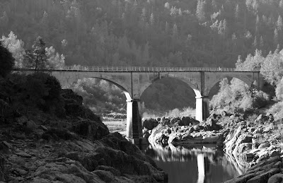
The drop to the river is 150 feet.
Here's a pencil drawing I did of the bridge:

Here's a photo of it:

Saturday, June 30, 2012
Hike to Tinker Knob
 |
| The crest of the Sierra, view south to Anderson Peak |
Today I hiked a small section of the Pacific Crest Trail, some seven miles from Donner Pass to Tinker Knob. The Trail extends 2,650 miles from the border of Mexico to the border of Canada. The Pacific Crest Trail Association says that an average of 300 hikers attempt the entire route each year. (And about 180 finish.) I spoke with six of them. The first two were in their late twenties or early thirties. The man was from Norway and the woman was from Wisconsin. I don't know if they were a couple or had informally joined up. The hikers start at Campo, California, either alone or in groups, and along the way they form informal partnerships, to share information and to check on each other's welfare. Since there is a window of time to do the hike, the hikers depart in April, and the wave of hikers was now passing through this area. The next man I met was in his late twenties. He was from Houston and worked in home remodeling, but with a shortage of work he was taking these several months to hike the trail. I met the other three hikers on my return from Tinker Knob. They were walking at a pace far faster than mine and they overtook me. They were less talkative than the others, but I learned that the couple was from England and the other hiker was from Palm Springs. The man was in his early twenties and the couple was in their late twenties. To hike the entire trail, one must be in top physical shape, and being young is a plus.
I saw a total of about thirty people on the trail. There were groups of runners. They park a vehicle at the Squaw Valley Ski Resort, drive to Donner Summit, and then run the trail (average elevation around 8,000 feet) to Squaw Valley. Others, like me, were out for a simple day hike.
I stopped at Roller Pass to look down the slope. The overland emigrants, after crossing prairies and deserts, noted in their diaries the dread they felt upon reaching their greatest obstacle, the wall of the Sierra Nevada. Roller Pass saw use from 1847 to 1850. It was less arduous than the Donner Pass crossing to north, where wagons had to be disassembled before being hoisted up the cliffs. With a 400 foot chain set over a log (the roller), the emigrants used double teams of oxen to bring their wagons up the slope. Once at the top, it was pretty much all downhill (but still a difficult journey) to the Sacramento Valley. The interpretive sign at Roller Pass stated that a little under 10,000 emigrants used this route.
 |
| View north to Roller Pass, Mount Judah in the background |
I continued my hike south to Tinker Knob. There were still large patches of snow blocking sections of the trail. One simply walks around them.

Tinker Knob is the core of a long dead volcano. The summit (8,949 feet) is reached by a bit of scrambling - there is no defined trail. The slope is steep and one must pay attention. Once at the top, the scenery is magnificent. Tucked amongst some rocks is a military ammo can with log books. I read my July 19, 2009 (10:52 AM) entry where I mentioned my bear encounter down by the ski lifts. I logged myself in for this hike. Another hiker reached the summit and we talked for some ten minutes. He then departed, to return to Donner Summit. I took some more photographs, gathered my gear, and left. Going down the slope of Tinker Knob takes more caution than going up.
 |
| Tinker Knob, 1.2 miles away, seen from Anderson Peak |
The only thing of note on the return hike was the wind, the steady relentless west wind blasting over the crest. But, in all, a nice hike for this day.
Tuesday, June 26, 2012
Early Summer Early Evening Foothills Walk
The summer solstice passed but a few days ago and the days are slowly getting shorter, but there is plenty of light after the workday ends to get some nice walks in the foothills around Auburn. And the angle of the sunlight on the hillsides provides some good photographs.
Here are some photos taken today along Stagecoach Trail, part of a toll road built in the 1850s to connect the county seat of Auburn and the mining town of Iowa Hill.
Unfortunately on this walk, the sunlight did not allow for a good photograph of a particular outcrop of metavolcanic rocks. (I'll get a photo later.) The folding and twisting of these rocks attest to the incredible subduction forces that created these parts. The rocks began as oceanic volcanoes hundreds of miles to the west, and were jammed into place here in the Jurassic Period, some 145 to 199 million years ago.
Or, if you take a fundamentalist view of things, just a few thousand years ago.


Update: I returned to Stagecoach Trail to get photos of the outcrop of metavolcanic rocks. Here's the outcrop from a distance.

And here are closer views.


Here are some photos taken today along Stagecoach Trail, part of a toll road built in the 1850s to connect the county seat of Auburn and the mining town of Iowa Hill.
Unfortunately on this walk, the sunlight did not allow for a good photograph of a particular outcrop of metavolcanic rocks. (I'll get a photo later.) The folding and twisting of these rocks attest to the incredible subduction forces that created these parts. The rocks began as oceanic volcanoes hundreds of miles to the west, and were jammed into place here in the Jurassic Period, some 145 to 199 million years ago.
Or, if you take a fundamentalist view of things, just a few thousand years ago.


_______________________________________________________________
Update: I returned to Stagecoach Trail to get photos of the outcrop of metavolcanic rocks. Here's the outcrop from a distance.

And here are closer views.


Subscribe to:
Posts (Atom)