Thursday, November 10, 2016
Wednesday, November 9, 2016
Oh Happy Day
Today as I went about my business, every so often I'd remember that Donald Trump is the president-elect, and I'd start laughing.


Saturday, October 29, 2016
Dia de los Muertos

Looking for something to raise our spirits what with all the recent dreadful weather, my wife and I went to the annual Day of the Dead celebration in downtown Sacramento. Normally this is held outdoors but the rains forced it into a parking garage. Still, there were crowds aplenty. This is a Mexican cultural event and most attendees were of Mexican heritage. The Mexican Consulate in Sacramento had a booth. Many of the Anglo visitors were of the liberal persuasion, judging by the serene look on their faces that screamed "Oh! All this multiculturalism!" One white man wore a tee shirt denouncing racism, while being surrounded by folks who identify as La Raza - The Race. Wearing a Trump Make America Great Again cap here would have been foolhardy at best. Taxpayer dollars were being spent having young people in khaki AmeriCorps uniforms help with the event, showing folks how to paint small skulls, that kind of stuff. How sad it is that these youngsters will leave AmeriCorps thinking they engaged in useful work. Better had they spent their time unloading trucks at the receiving dock of a major retail store, to get a taste of what real world work is like. The parking meter was running and I can't be frivolous on things such as personal fun when the government needs my money to give to others. So my wife and I left the parking garage and walked to our car, the sound of mariachi music fading in the distance.
Saturday, October 1, 2016
Three Trees on the Trail
Today I hiked Euchre Bar Trail, my goal the Southern Cross Mine, but when I reached the third downed tree, I decided to turn around.
 |
| Iron Point Trailhead |


Some twenty minutes after crossing the river, I reached a downed pine tree with a trunk diameter of about thirty inches. The needles were still green. The roots, now reaching into the air, had taken up large chunks of slate. The slate is part of the Shoo Fly complex, the oldest rocks of the Sierra Nevada, and in the slate can be found veins of quartz containing gold. I looked for quartz in this exposed slate, but saw none. I wound around the roots, crawled over the trunk, and continued on my hike.


I reached the second fallen tree, which I had seen on my last hike here (2014, I think). The bark had fallen off the trunk. I crawled over the trunk and continued on.
This section of trail is very beautiful, with the several emerald-green pools below. I passed a pile of stones at a level spot overlooking the river. I'm sure the Forty Niners put up these stones for a cabin or tent site during the Gold Rush. About the ground are chunks of quartz the miners pulled out of the hillsides. The rocks are now covered in moss.


A bit later I reached the third downed tree, too large to crawl over. Others had made a path up and over the roots. I looked at this obstacle and considered my situation. I was by myself, the mine was a good half mile away, and there might be more downed trees. If I needed to reach the mine, I could try the route from Foresthill Divide through Dorer Ranch. I considered everything, and decided to have lunch at my gold panning spot.

 |
| View from the trail to my gold panning spot |
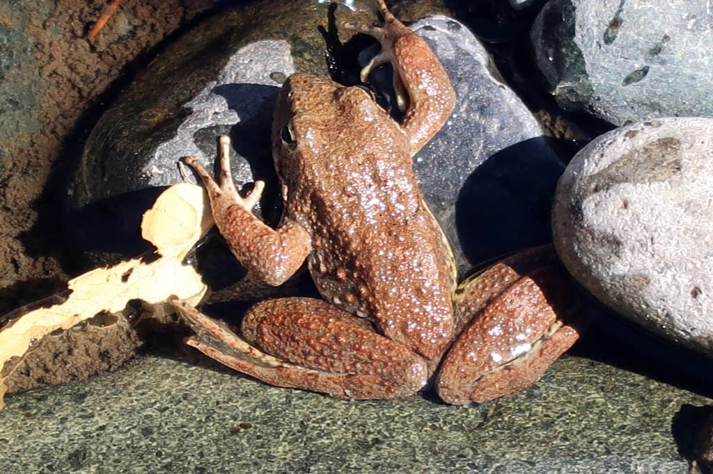
The river was at the lowest level I had ever seen, a good two feet below normal judging from the moss on the rocks. I'll return soon with a bucket, shovel, and gold pan, but today I simply enjoyed the scenery. Small trout rose to the surface. Frogs hopped about. During spring snow melts, in years without drought, I've seen the river running so hard that getting caught in the current meant certain death, and I've heard the clunk of boulders the size of basketballs moving downstream. But today I could have crossed the river without getting my knees wet. I finished my lunch and poked around the bar. People camp here. Someone had left behind a piece of quartz taken from a nearby vein. I'm sure they had taken several pieces, but left this one as it contained so little gold it was not worth carrying out of the canyon. I left the rock, so that others could find it and see the gold. Also at the bar was the rusted wheel of an ore cart from some mine around here.


 |
| Gold-bearing quartz |
I wonder if this is where Thomas Lane met his end. From the Daily Alta California of July 2, 1855:

I made the 1800 foot ascent without needing to stop and rest. I did briefly talk with two men in their thirties hiking down to the river, the only others I saw on the trail this day. They didn't intend to go beyond the bridge. Few people do. Here may be the reason the trail from Iron Point to the river is well maintained, while the section from the river to Dorer Ranch is blocked with downed trees - it's a matter of use. Or maybe the Forest Service doesn't have the staffing or funds to remove those large trees. (The Forest Service website says that no trail maintenance has been done since 2013.) Perhaps it's intentional neglect. This is a designated Wild and Scenic River, and since few use the section of trail, why not let it revert to its wild state?
Saturday, July 30, 2016
Veterans of World War I

This board inside the Auburn Veterans Memorial Hall (built 1931, dedicated January 1932) tells us of the existence of Auburn Barracks 570, Veterans of World War I.
The Veterans of World War I of the U.S.A., Inc. was organized in 1948 and incorporated by Congress in 1958. It was a fraternal, civic, and social organization, with a constitution, by-laws, and rituals similar to those of the Grand Army of the Republic and the American Legion. The organization dissolved following the death in 2011 of its National Commander and last remaining member, Frank Woodruff Buckles, who was also the last surviving American veteran of World War I.
The board in Auburn has the first entry dated 1956. The last year with a Barracks Commander is 1986. The last year with an Auxiliary President (a veteran's wife) is 1989.

Saturday, July 16, 2016
Tinker Knob
Two years ago I hiked to Tinker Knob but found no safe route to the summit. This was a bit frustrating, for I had stood atop the summit two or three times before. Today I returned and reached the top.
Tinker Knob is the core of an extinct volcano at the crest of the Sierra Nevada in Placer County. It sits along the Pacific Crest Trail, and is a popular hiking destination. The elevation is 8,949 feet. The slopes are rocky and steep. A short path from the Pacific Crest Trail reaches the base, then it splits into several paths. Only one (as far as I know) goes to the summit. Absent finding this path, scrambling is required to reach the top.
I departed the trailhead at Donner Pass at 6:20 AM, my destination about 7.5 miles away. I walked in solitude until 7:05, when I passed the first hikers, a father and his teenage son. Many trees on this first section of trail are bent at the base from the weight of deep snow on the steep slopes.


I reached the base of Mt. Lincoln at 7:55. The going would be fairly level from here to the approach of Anderson Peak. Patches of snow still blocked parts of the trail.

Tinker Knob came into view as I rounded Anderson Peak. By now I had passed about ten hikers who told me they were going the entire length of the Pacific Crest Trail, from Mexico to Canada.


At 11:00 I was at the base of Tinker Knob. I took two paths that led to large rocks on steep inclines that I didn't want to tackle, then I saw a young couple taking a route that involved some scrambling. I followed them and was soon on the summit.
At the summit is a military ammunition can that holds small notebooks. In one notebook I found my entry for July 31, 2010: "Second time here. Great!" I signed in to the current notebook.
The couple I followed to the top stayed but a few minutes. I talked with a group of hikers who were at the top when I arrived. Soon we were joined by Rob, a man in his fifties who lives in nearby Truckee. He had been to Tinker Knob the previous Saturday, and he said he goes there several times a year. He had started his hike at Donner Pass, and would finish it at Squaw Valley.
A woman in the group did a yoga headstand.

Here are the sights from the summit. Rob said that on a clear day one can see the mountains of the Coastal Range across the Sacramento Valley. I told him that Tinker Knob can be seen from Iron Point, the starting point of Euchre Bar Trail, near Alta.
With my Kenwood TH-F6 2-meter radio, I called the W6EK repeater in Auburn, and got a response from a ham operator in Winters. Later, at the base of Anderson Peak, I heard Richard WA6RWS on the repeater, and I made contact with him. Richard and I are members of the Sierra Foothills Amateur Radio Club.
I met a man hiking the entire length of the Pacific Crest Trail, having started in early May. He was checking the news on his smart phone. Reception on the trail is limited. He had last heard about the coup attempt in Turkey, but not that the coup had failed.

I reached my truck at four o'clock.
Tinker Knob is the core of an extinct volcano at the crest of the Sierra Nevada in Placer County. It sits along the Pacific Crest Trail, and is a popular hiking destination. The elevation is 8,949 feet. The slopes are rocky and steep. A short path from the Pacific Crest Trail reaches the base, then it splits into several paths. Only one (as far as I know) goes to the summit. Absent finding this path, scrambling is required to reach the top.


I reached the base of Mt. Lincoln at 7:55. The going would be fairly level from here to the approach of Anderson Peak. Patches of snow still blocked parts of the trail.

Tinker Knob came into view as I rounded Anderson Peak. By now I had passed about ten hikers who told me they were going the entire length of the Pacific Crest Trail, from Mexico to Canada.


At 11:00 I was at the base of Tinker Knob. I took two paths that led to large rocks on steep inclines that I didn't want to tackle, then I saw a young couple taking a route that involved some scrambling. I followed them and was soon on the summit.
At the summit is a military ammunition can that holds small notebooks. In one notebook I found my entry for July 31, 2010: "Second time here. Great!" I signed in to the current notebook.
The couple I followed to the top stayed but a few minutes. I talked with a group of hikers who were at the top when I arrived. Soon we were joined by Rob, a man in his fifties who lives in nearby Truckee. He had been to Tinker Knob the previous Saturday, and he said he goes there several times a year. He had started his hike at Donner Pass, and would finish it at Squaw Valley.
A woman in the group did a yoga headstand.

Here are the sights from the summit. Rob said that on a clear day one can see the mountains of the Coastal Range across the Sacramento Valley. I told him that Tinker Knob can be seen from Iron Point, the starting point of Euchre Bar Trail, near Alta.
 |
| View west, the canyon of the North Fork American River |
 |
| View north, the Pacific Crest Trail and Anderson Peak |
 |
| View south, Lake Tahoe |
With my Kenwood TH-F6 2-meter radio, I called the W6EK repeater in Auburn, and got a response from a ham operator in Winters. Later, at the base of Anderson Peak, I heard Richard WA6RWS on the repeater, and I made contact with him. Richard and I are members of the Sierra Foothills Amateur Radio Club.
I met a man hiking the entire length of the Pacific Crest Trail, having started in early May. He was checking the news on his smart phone. Reception on the trail is limited. He had last heard about the coup attempt in Turkey, but not that the coup had failed.

I reached my truck at four o'clock.
Tuesday, January 12, 2016
1850 Census
Along the stretch of the North Fork of the American River between Euchre Bar and Humbug Bar there is but one domicile, a house on Dorer Ranch. The Dorer family has occupied the site since the 1860s. They apparently value their privacy, for I hear that atop Foresthill Divide the gate across the dirt road that winds down to the house is kept locked. I've reached the Dorer property twice, hiking in along the river from Iron Point near Alta. Those walks on the Gold Rush-era trail were solitary, for few people venture into the deep canyons nowadays. But it wasn't always quiet down there. A bit over a century ago, the clanging from the stamp mills at the Southern Cross and Blackhawk mines reverberated throughout the canyon. A twenty-horse power gasoline engine generated electricity for the incandescent lights and telephone lines and air compressors of the Southern Cross. The greatest activity was in the early years of the Gold Rush, when miners worked the gravels. The level spots they dug into the hillsides to pitch their tents testify to their presence, and sometimes the ceramic shard of a bowl or cup may be found. As far as I know, only the Nisenan walked this area before the Gold Rush - I've found nothing of Hudson Bay trappers coming this far upriver.
Would the 1850 Federal Census show the number of miners down at the river early in the Gold Rush? Today I went to the Placer County Archives to find out. Placer County didn't exist in 1850 - it was formed in 1851 from portions of Sutter and Yuba counties. The archivist provided the microfilm and I scanned the documents for both counties. Names of Americans were listed along with their home state. Others had no name, only a listing such as Kanaka and Chinaman and Spaniard. Occupations were listed, most being Miner. But there was nothing to indicate which portions of the census were taken at the river, so we can only speculate as to how crowded it was in the canyons long ago.
Would the 1850 Federal Census show the number of miners down at the river early in the Gold Rush? Today I went to the Placer County Archives to find out. Placer County didn't exist in 1850 - it was formed in 1851 from portions of Sutter and Yuba counties. The archivist provided the microfilm and I scanned the documents for both counties. Names of Americans were listed along with their home state. Others had no name, only a listing such as Kanaka and Chinaman and Spaniard. Occupations were listed, most being Miner. But there was nothing to indicate which portions of the census were taken at the river, so we can only speculate as to how crowded it was in the canyons long ago.
Subscribe to:
Comments (Atom)